Lanzhou Completes Emergency Survey in Key Areas After Heavy Rain and Flash Floods
Lanzhou Completes Emergency Survey in Key Areas After Heavy Rain and Flash Floods
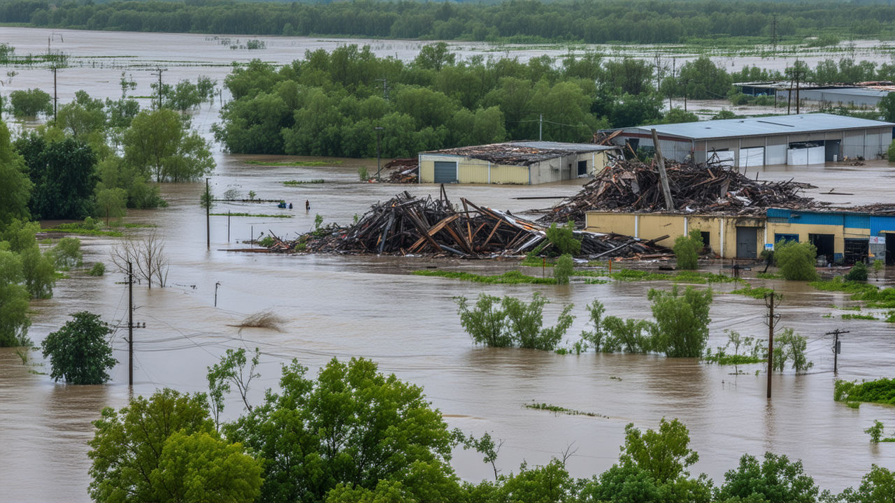
In the wake of severe flooding in Lanzhou, emergency teams have completed preliminary investigations in several key areas, providing crucial data for disaster response and recovery efforts.
Emergency Response Underway
On the evening of August 8, 2025, a press conference was held in Yuzhong County, Lanzhou, to update the public on the latest developments regarding the flash flood disaster. The event provided updates on rescue operations, the relocation of affected residents, and the medical care of the injured.
According to the vice director of the Gansu Provincial Department of Natural Resources, a team of 112 technical personnel has been deployed to the affected areas. They have brought with them 22 drones, 33 vehicles, 13 satellite phones, and two data processing workstations. The team is conducting emergency investigations in three key river basins: Wangya Gou, Huangya Gou, and Jiugou Village.
As of 5:50 p.m., the team has completed the processing of 12 satellite image data sets from the GF-2 and GF-1 satellites and the Jilin-1 constellation, collected in July 2025. These images have been analyzed for three major flash flood basins, with a resolution of 0.8 meters and 0.5 meters. Additionally, the team has gathered over 500 aerial photographs of the Xinglong River Basin using drones.
Emergency teams have completed the creation of an aerial orthographic image map of the Xinglong River Basin. SAR data has also been collected for the Ma Lian Tan village in Mapo Township, and preliminary analysis of pre- and post-disaster conditions has been conducted. The focus has been on severely damaged buildings (35 identified areas, with 10 suspected severely affected regions), the current state of floodwaters, primary flow direction, and the overall affected area.
According to the latest progress, emergency investigations in Wangya Gou and Huangya Gou are expected to be completed by 9 a.m. on the morning of August 9. However, Jiugou Village is currently inaccessible due to road blockages, and survey teams are walking to the site to continue their work.
Once the main disaster areas have been fully surveyed, the team will move on to inspect other regions for potential geological hazards. This information will be critical in planning the next steps in recovery and prevention efforts.
Importance of Timely Data Collection
The use of advanced technologies such as drones and satellite imagery has significantly improved the speed and accuracy of the emergency response. This kind of data not only helps in immediate recovery efforts but also provides long-term insights for disaster preparedness and infrastructure planning.
The collaboration between various departments and the deployment of cutting-edge technology highlight the importance of a multi-agency, tech-driven approach to managing natural disasters. As the region continues to recover, it is crucial that these lessons are applied to future planning and risk mitigation strategies.
Community and Future Preparedness
While the immediate focus remains on rescue and relief, the data gathered from these emergency surveys will also be instrumental in assessing long-term risks and developing more resilient communities. The government is expected to use this information to improve early warning systems and infrastructure in the region.
Residents are being relocated to safer areas, and medical teams are working tirelessly to treat the injured. The ongoing efforts of the emergency teams and the support from the local community are key to overcoming the challenges posed by this disaster.
Conclusion
The successful completion of emergency surveys in key areas marks a significant step forward in the recovery process. As the teams continue their work in the affected regions, the collected data will play a vital role in shaping future disaster response strategies and ensuring the safety and well-being of the local population.
With the support of the government and the resilience of the people, the region is on the path to recovery. The lessons learned from this disaster will undoubtedly contribute to more effective preparedness and response in the years to come.